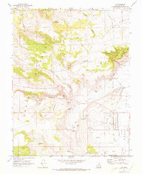
1969 Map of Loa
USGS Topo · Published 1973About this map
Rabbit Valley and the surrounding high-elevation terrain define this late 1960s study of the Utah interior. The settlement of Loa serves as the focal point for the region's agricultural and civic life, situated near the Fremont River and supported by a network of water resources including the Allred Ditch, Flowing Wells, and numerous named springs like Bullberry Spring and Potter Spring. The landscape transitions from the developed valley floor to the protected lands of the Fishlake National Forest, where features such as Black Ridge and the Row of Pines Bench mark the rising plateau. Local infrastructure is well-represented, from the Fish Hatchery and Rodeo Grounds to the Loa Cem and Fremont Cem, providing significant detail for those tracing the development of Wayne County's early irrigation and grazing systems.
Find a feature on this map
41 named features on this map. Tap any name to fly to it.
Don’t see what you’re looking for? This feature index may not catch every label — zoom into the map to look around manually.
Map Details
Editions of this 1969 Loa Map
2 editions found
Other maps of this area

1885 · Fish Lake
USGS Topo · 1:250,000

1896 · Fish Lake
USGS Topo · 1:250,000

1952 · Loa 1 SE
USGS Topo · 1:24,000

1952 · Loa 1 NE
USGS Topo · 1:24,000

1956 · Salina
USGS Topo · 1:250,000

1960 · Salina
USGS Topo · 1:250,000

1962 · Salina
USGS Topo · 1:250,000

1967 · Lyman
USGS Topo · 1:24,000

1968 · Fish Lake
USGS Topo · 1:24,000
1968 · Burrville
USGS Topo · 1:24,000