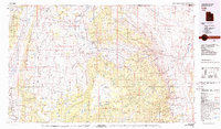
1980 Map of Loa
USGS Topo · Published 1980About this map
Loa and the surrounding high plateaus of south-central Utah are meticulously documented in this 1980 survey, illustrating a landscape defined by dramatic geological transitions and scattered rural settlements. The map traces the upper reaches of the Fremont River, which connects a string of valley towns including Lyman, Bicknell, and Torrey before cutting through the complex topography of Capitol Reef National Park. To the west, the Awapa Plateau and Parker Mountain dominate the terrain, while the massive Aquarius Plateau and Boulder Mountain rise to the south, dotted with high-altitude water bodies like Blind Lake and Posey Lake. The distribution of small mountain reservoirs, such as Oak Creek Reservoir and Donkey Reservoir, reflects the vital water management necessary for the region's agricultural and ranching life. This survey provides a clear view of the road network, including Utah 24, as it skirts the striking Waterpocket Fold and enters the desert expanses of Caineville Wash.
Find a feature on this map
61 named features on this map. Tap any name to fly to it.
Don’t see what you’re looking for? This feature index may not catch every label — zoom into the map to look around manually.
Map Details
Editions of this 1980 Loa Map
2 editions found
Other maps of this area

1885 · San Rafael
USGS Topo · 1:250,000

1885 · Beaver
USGS Topo · 1:250,000

1885 · Fish Lake
USGS Topo · 1:250,000

1886 · Kanab
USGS Topo · 1:250,000

1886 · Escalante
USGS Topo · 1:250,000

1886 · Henry Mountains
USGS Topo · 1:250,000

1892 · Henry Mountains
USGS Topo · 1:250,000

1896 · Fish Lake
USGS Topo · 1:250,000

1940 · Monroe
USGS Topo · 1:62,500

1944 · Monroe
USGS Topo · 1:62,500