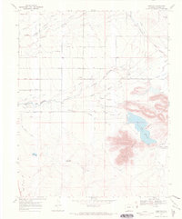
1967 Map of Lobatos
USGS Topo · Published 1971About this map
Agricultural life in southern Colorado is defined by a dense network of water engineering, as seen in this 1967 survey of the land south of the North Branch Conejos River. The map meticulously charts dozens of irrigation channels, including the Manassa Ditch, Valdez Ditch, and Heads Mill Ditch, which sustain the high-desert valley floor. This intricate system feeds local landmarks like Cove Lake Reservoir and Alta Lake, supporting ranching operations such as T Bone Ranch and the small settlement of Lobatos. The terrain is punctuated by the South Hills and the winding course of the Rio San Antonio. On the western edge of the quadrangle, an Old Railroad Grade provides a clear record of former transportation corridors that once linked these isolated ranching outposts and settlements like Saritas to the wider region.
Find a feature on this map
42 named features on this map. Tap any name to fly to it.
Don’t see what you’re looking for? This feature index may not catch every label — zoom into the map to look around manually.
Map Details
Editions of this 1967 Lobatos Map
3 editions found
Other maps of this area

1918 · Tusas
USGS Topo · 1:125,000

1922 · Conejos
USGS Topo · 1:125,000

1945 · Durango
USGS Topo · 1:250,000

1953 · Durango
USGS Topo · 1:250,000

1954 · Durango
USGS Topo · 1:250,000

1954 · Raton
USGS Topo · 1:250,000

1954 · Trinidad
USGS Topo · 1:250,000

1954 · Aztec
USGS Topo · 1:250,000

1955 · Trinidad
USGS Topo · 1:250,000

1958 · Raton
USGS Topo · 1:250,000