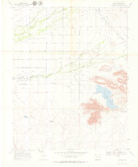
1967 Map of Lobatos
USGS Topo · Published 1979About this map
Lobatos serves as the primary hub in this high-plains landscape where the Rio San Antonio and Conejos River define the local drainage patterns. The geography is characterized by an extensive network of human-made water diversions, including the Heads Mill Ditch, Servietta Ditch, and Taos Valley Canal, reflecting the critical importance of irrigation to the ranching economy. To the southeast, the Pinon Hills rise above the basin floor, near where the Cone Reservoir is noted as dry at the time of the 1967 field check. Local history and genealogy interests are centered around the Lobatos Cem and established homesteads like T Bone Ranch. Geologic features such as the Kaoline Sericite deposit and several named wells, including the Old Lantern Well, indicate the diverse natural resources and subsurface exploration in this part of Conejos County.
Find a feature on this map
36 named features on this map. Tap any name to fly to it.
Don’t see what you’re looking for? This feature index may not catch every label — zoom into the map to look around manually.
Map Details
Editions of this 1967 Lobatos Map
3 editions found
Other maps of this area

1918 · Tusas
USGS Topo · 1:125,000

1922 · Conejos
USGS Topo · 1:125,000

1945 · Durango
USGS Topo · 1:250,000

1953 · Durango
USGS Topo · 1:250,000

1954 · Durango
USGS Topo · 1:250,000

1954 · Raton
USGS Topo · 1:250,000

1954 · Trinidad
USGS Topo · 1:250,000

1954 · Aztec
USGS Topo · 1:250,000

1955 · Trinidad
USGS Topo · 1:250,000

1958 · Raton
USGS Topo · 1:250,000