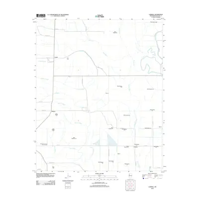
2012 Map of Lobdell
USGS Topo · Published 2012About this map
The alluvial plains of Bolivar County, Mississippi, are defined by an intricate network of drainage systems and natural waterways such as Bogue Phalia and Stokes Bayou. In this early 21st-century landscape, the transition from old river-bend topography to modern industrial agriculture is visible through the myriad of numbered drainage ditches, including Ditch Number Eight and Ditch Number C-14, which crisscross the flat delta terrain. Small settlements like Lobdell, Dahomy, and Longshot remain as anchors in this rural expanse, often situated near family-named landmarks and cemeteries like Polk-Royal Cem and Egypt Ridge Cem. Local aviation is represented by the West Bolivar Flying Service Airport, reflecting the region's reliance on aerial application for farming. The map traces historical water paths like Christmas Lake Br and Ann Bayou as they wind through a grid of local routes such as Litton Rd and Neblett Rd.
Find a feature on this map
55 named features on this map. Tap any name to fly to it.
Don’t see what you’re looking for? This feature index may not catch every label — zoom into the map to look around manually.
Map Details
Editions of this 2012 Lobdell Map
This is the sole edition of this map. No revisions or reprints were ever made.
Other maps of this area

1933 · Lamont
USGS Topo · 1:62,500

1939 · Pace
USGS Topo · 1:62,500

1939 · Big Island
USGS Topo · 1:62,500

1939 · Lamont
USGS Topo · 1:62,500

1939 · Choctaw
USGS Topo · 1:62,500

1953 · Greenwood
USGS Topo · 1:250,000

1956 · Greenwood
USGS Topo · 1:250,000

1967 · Stringtown
USGS Topo · 1:24,000
1967 · Skene
USGS Topo · 1:24,000
1967 · Shaw
USGS Topo · 1:24,000