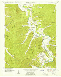
1950 Map of Lobelville
USGS Topo · Published 1953About this map
Lobelville serves as the central hub of this mid-century survey, situated along the winding course of the Buffalo River. The landscape is defined by the deep dissection of Dividing Ridge and Dumony Ridge, where countless hollows like Hellsneck Hollow and Pea Hollow give way to fertile lowlands such as Owen Bottom and Rains Bottom. The geography reflects a late-transition period in rural Tennessee, where traditional landmarks like Standing Rock and Buffalo Ch coexist with modern infrastructure like a Radio tower and Gaging station. Genealogists will find a wealth of family history across the terrain, with numerous burial sites including the Dodson Cemeteries, Davidson Hester Cem, and Leeper Cem scattered near the river's Leeper Bottom. The network of bridges, including Mill Bridge and Gilmore Bridge, illustrates the historical reliance on these river crossings for connecting the communities of Perry County.
Find a feature on this map
87 named features on this map. Tap any name to fly to it.
Don’t see what you’re looking for? This feature index may not catch every label — zoom into the map to look around manually.
Map Details
Editions of this 1950 Lobelville Map
3 editions found
Other maps of this area

1936 · Pleasantville
USGS Topo · 1:24,000

1936 · Hurricane Mills
USGS Topo · 1:24,000

1936 · Coble
USGS Topo · 1:24,000

1936 · Pine View
USGS Topo · 1:24,000

1936 · Daniels Landing
USGS Topo · 1:24,000

1936 · Bucksnort
USGS Topo · 1:24,000

1936 · Chestnut Grove
USGS Topo · 1:24,000

1936 · Lobelville
USGS Topo · 1:24,000

1936 · Hustburg
USGS Topo · 1:24,000

1949 · Daniels Landing
USGS Topo · 1:24,000