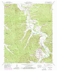
1950 Map of Lobelville
USGS Topo · Published 1988About this map
The Buffalo River snakes through the heart of Perry County, carving a valley defined by broad flats like Squeeze Bottom and Leeper Bottom. The town of Lobelville serves as the central hub, situated where the river makes a sharp bend near the Lobelville Lookout Tower. This 1950s-era landscape, updated with 1968 aerial data, reveals a community deeply rooted in its geography, with numerous family burial grounds such as Davidson Hester Cem and Dodson Cems scattered across the ridgelines and hollows.
Find a feature on this map
81 named features on this map. Tap any name to fly to it.
Don’t see what you’re looking for? This feature index may not catch every label — zoom into the map to look around manually.
Map Details
Editions of this 1950 Lobelville Map
3 editions found
Other maps of this area

1936 · Pleasantville
USGS Topo · 1:24,000

1936 · Hurricane Mills
USGS Topo · 1:24,000

1936 · Coble
USGS Topo · 1:24,000

1936 · Pine View
USGS Topo · 1:24,000

1936 · Daniels Landing
USGS Topo · 1:24,000

1936 · Bucksnort
USGS Topo · 1:24,000

1936 · Chestnut Grove
USGS Topo · 1:24,000

1936 · Lobelville
USGS Topo · 1:24,000

1936 · Hustburg
USGS Topo · 1:24,000

1949 · Daniels Landing
USGS Topo · 1:24,000