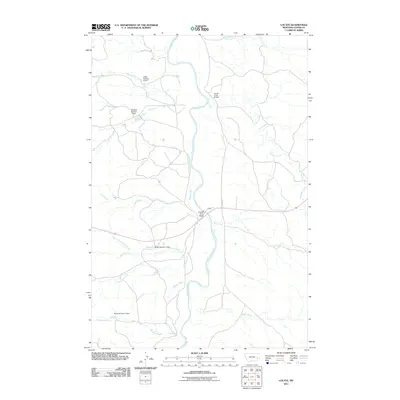
2011 Map of Locate
USGS Topo · Published 2011About this map
The Powder River meanders northward through this eastern Montana landscape, forming a wide alluvial valley defined by its intricate drainage network. The settlement of Locate sits at the intersection of local routes, serving as a focal point for the surrounding ranching and agricultural operations. Water management is a primary feature of the terrain, evidenced by several family-named earthen works such as the Griffin Number 2 Dam, Odegard Number 2 Dam, and multiple Bixler-named reservoirs.
Find a feature on this map
22 named features on this map. Tap any name to fly to it.
Don’t see what you’re looking for? This feature index may not catch every label — zoom into the map to look around manually.
Map Details
Editions of this 2011 Locate Map
This is the sole edition of this map. No revisions or reprints were ever made.
Other maps of this area

1953 · Miles City
USGS Topo · 1:250,000

1957 · Miles City
USGS Topo · 1:250,000

1958 · Miles City
USGS Topo · 1:250,000

1969 · Corral Butte
USGS Topo · 1:24,000

1969 · Spring Draw
USGS Topo · 1:24,000

1969 · Hogan Creek
USGS Topo · 1:24,000

1969 · Locate SE
USGS Topo · 1:24,000

1969 · Flat Top Butte SW
USGS Topo · 1:24,000

1969 · Buck Mountain
USGS Topo · 1:24,000
1969 · Red Knob
USGS Topo · 1:24,000