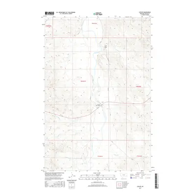
2017 Map of Locate
USGS Topo · Published 2017About this map
The Powder River meanders through the heart of this Custer County landscape, defining the character of the settlement at Locate. This isolated outpost serves as a critical crossing point, where the Powder River Bridge and Locate Creek Bridge facilitate movement across the river's extensive floodplain and its many tributaries. The area is marked by a complex network of drainage systems, including Wolf Cr, Deep Cr, and Smith Cr, which carve through the surrounding terrain.
Find a feature on this map
27 named features on this map. Tap any name to fly to it.
Don’t see what you’re looking for? This feature index may not catch every label — zoom into the map to look around manually.
Map Details
Editions of this 2017 Locate Map
This is the sole edition of this map. No revisions or reprints were ever made.
Other maps of this area

1953 · Miles City
USGS Topo · 1:250,000

1957 · Miles City
USGS Topo · 1:250,000

1958 · Miles City
USGS Topo · 1:250,000

1969 · Corral Butte
USGS Topo · 1:24,000

1969 · Spring Draw
USGS Topo · 1:24,000

1969 · Hogan Creek
USGS Topo · 1:24,000

1969 · Locate SE
USGS Topo · 1:24,000

1969 · Flat Top Butte SW
USGS Topo · 1:24,000

1969 · Buck Mountain
USGS Topo · 1:24,000
1969 · Red Knob
USGS Topo · 1:24,000