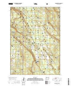
2020 Map of Location Butte
USGS Topo · Published 2020About this map
Winema National Forest and Fremont National Forest meet in this high-altitude landscape of Klamath County, characterized by a series of springs and seasonal water sources. The namesake Location Butte rises as a central landmark above a network of drainages and meadows including Parker Meadow and the aptly named Bear Wallow. Human presence is marked by scattered improvements such as Dicks Camp Spring and Cliff Spring Reservoir, reflecting the area's history of forest management and seasonal grazing. The terrain is defined by dry features like Sagebrush Flat and Sagebrush Draw, which transition into the drainage of Rock Cr to the south. This topographic study reveals the remote character of the eastern Cascades, where water management at sites like Bull Jack Spring and Mud Spring remains vital for the surrounding forest ecosystem.
Find a feature on this map
18 named features on this map. Tap any name to fly to it.
Don’t see what you’re looking for? This feature index may not catch every label — zoom into the map to look around manually.
Map Details
Editions of this 2020 Location Butte Map
This is the sole edition of this map. No revisions or reprints were ever made.
Other maps of this area

1935 · Chemult
USGS Topo · 1:96,000

1941 · Chemult
USGS Topo · 1:125,000

1955 · Crescent
USGS Topo · 1:250,000

1957 · Crescent
USGS Topo · 1:250,000

1958 · Crescent
USGS Topo · 1:250,000
1967 · Sellers Marsh
USGS Topo · 1:24,000

1968 · Location Butte
USGS Topo · 1:24,000

1968 · Rodman Rock
USGS Topo · 1:24,000
1968 · Antelope Mtn
USGS Topo · 1:24,000
1968 · Sugarpine Mtn.
USGS Topo · 1:24,000