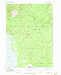
1968 Map of Sugarpine Mtn.
USGS Topo · Published 1971About this map
Winema National Forest encompasses this high-elevation landscape, where volcanic topography and expansive wetlands meet in northern Klamath County. The western edge of the map is dominated by the Klamath Marsh, a critical ecological feature flanked by Sagebrush Point and the waters of Silver Lake. Historical land use is evidenced by the Old Indian Treaty Bdy cutting across the northern sections, while the presence of the Old Railroad Grade near the marsh indicates the era of heavy timber extraction that once moved through these woods. Diverse water sources including Indian Spring, Kicking Horse Spring, and Deer Scaffold Spring dot the terrain, which rises toward the prominent peak of Sugarpine Mtn. Remnants of past forest fires are marked by the Sugarpine Burn, Bedpan Burn, and Junction Burn, illustrating the cycles of growth and disturbance in this timber-rich region.
Find a feature on this map
28 named features on this map. Tap any name to fly to it.
Don’t see what you’re looking for? This feature index may not catch every label — zoom into the map to look around manually.
Map Details
Editions of this 1968 Sugarpine Mtn. Map
This is the sole edition of this map. No revisions or reprints were ever made.
Other maps of this area

1889 · Klamath
USGS Topo · 1:250,000

1894 · Klamath
USGS Topo · 1:250,000

1935 · Chemult
USGS Topo · 1:96,000

1941 · Chemult
USGS Topo · 1:125,000

1955 · Crescent
USGS Topo · 1:250,000

1955 · Klamath Falls
USGS Topo · 1:250,000

1957 · Crescent
USGS Topo · 1:250,000

1957 · Klamath Marsh
USGS Topo · 1:62,500

1958 · Crescent
USGS Topo · 1:250,000

1958 · Klamath Falls
USGS Topo · 1:250,000