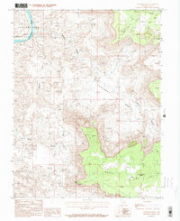
1987 Map of Lockhart Basin
USGS Topo · Published 1987About this map
Canyonlands National Park and the rugged expanse of Lockhart Basin dominate this high-desert landscape in San Juan County. Surveyed by the U.S. Geological Survey in the 1980s, the map tracks the path of the Colorado River as it cuts through the northwestern corner of the quadrangle. Significant elevation changes are marked by dramatic landmarks such as Hatch Point and the Needles Overlook, providing a detailed look at the canyon systems of Lockhart Canyon, Horsethief Canyon, and Rustler Canyon. Evidence of human activity is sparse but notable, including a Prospect site and a Spring, reflecting the remote and challenging environment of the Colorado Plateau. The survey also captures the distinctive Horsehead Rock, a prominent feature within the intricate network of mesas and drainage basins that define this region.
Find a feature on this map
12 named features on this map. Tap any name to fly to it.
Don’t see what you’re looking for? This feature index may not catch every label — zoom into the map to look around manually.
Map Details
Editions of this 1987 Lockhart Basin Map
This is the sole edition of this map. No revisions or reprints were ever made.
Other maps of this area

1885 · La Sal
USGS Topo · 1:250,000

1951 · Upheaval Dome
USGS Topo · 1:62,500

1952 · Carlisle 2 SE
USGS Topo · 1:24,000

1952 · Carlisle 2 NE
USGS Topo · 1:24,000

1953 · The Needles
USGS Topo · 1:62,500

1954 · Carlisle 4 NW
USGS Topo · 1:24,000

1954 · Carlisle 1 NE
USGS Topo · 1:24,000

1954 · Carlisle 1 SE
USGS Topo · 1:24,000

1954 · Carlisle 1 NW
USGS Topo · 1:24,000

1954 · Carlisle 4 NE
USGS Topo · 1:24,000