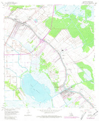
1963 Map of Lockport
USGS Topo · Published 1981About this map
Bayou Lafourche and the Southern Pacific railroad anchor the development of this South Louisiana corridor, where ribbon-like settlements follow the natural levees of the waterways. The landscape transition from agricultural land and drainage canals to the expansive Lake Fields is clearly visible, with numerous pumping stations and the Forty Arpent Canal managing the hydrology of the low-lying terrain. In Lockport and Raceland, concentrated residential and civic life is evidenced by Raceland High Sch, Raceland Ch, and New Fountain Cem. Beyond the town centers, the regional economy is represented by the Oil and Gas Field to the northeast and scattered infrastructure like the Filtration Plant and various waste ponds, reflecting the area's industrial and residential growth through the mid-20th century.
Find a feature on this map
48 named features on this map. Tap any name to fly to it.
Don’t see what you’re looking for? This feature index may not catch every label — zoom into the map to look around manually.
Map Details
Editions of this 1963 Lockport Map
4 editions found
Other maps of this area

1891 · Hahnville
USGS Topo · 1:62,500

1892 · Lac Des Allemands
USGS Topo · 1:62,500

1892 · Cut-Off
USGS Topo · 1:62,500

1892 · Houma
USGS Topo · 1:62,500

1932 · Houma SE
USGS Topo · 1:31,680

1932 · Lac Des Allemands SE
USGS Topo · 1:31,680

1932 · Lac Des Allemands SW
USGS Topo · 1:31,680

1932 · Houma SW
USGS Topo · 1:31,680

1932 · Houma NE
USGS Topo · 1:31,680

1932 · Houma NW
USGS Topo · 1:31,680