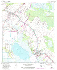
1963 Map of Lockport
USGS Topo · Published 1986About this map
Bayou Lafourche dictates the settlement pattern of this mid-century Louisiana landscape, with long, narrow ribbon-style land tracts extending perpendicularly from its banks. The map documents the dense concentration of infrastructure along the waterway, connecting Raceland in the northwest to Lockport in the southeast. This corridor is shared by the Southern Pacific railroad and numerous smaller communities like Mathews, Clotilda, and Rita.
Find a feature on this map
41 named features on this map. Tap any name to fly to it.
Don’t see what you’re looking for? This feature index may not catch every label — zoom into the map to look around manually.
Map Details
Editions of this 1963 Lockport Map
4 editions found
Other maps of this area

1891 · Hahnville
USGS Topo · 1:62,500

1892 · Lac Des Allemands
USGS Topo · 1:62,500

1892 · Cut-Off
USGS Topo · 1:62,500

1892 · Houma
USGS Topo · 1:62,500

1932 · Houma SE
USGS Topo · 1:31,680

1932 · Lac Des Allemands SE
USGS Topo · 1:31,680

1932 · Lac Des Allemands SW
USGS Topo · 1:31,680

1932 · Houma SW
USGS Topo · 1:31,680

1932 · Houma NE
USGS Topo · 1:31,680

1932 · Houma NW
USGS Topo · 1:31,680