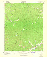
1967 Map of Lockwood
USGS Topo · Published 1968About this map
Lockwood and Lyonsville anchor the southern reaches of this landscape along the Otter Creek drainage, where the Penn Central rail line follows the valley floor. In the late 1960s, this portion of Nicholas County was defined by a heavy extractive footprint, seen in the numerous Strip Mine operations and Gas Well sites that dot the hollows from Cannel Coal Hollow to Twentymile Creek. These industrial features exist alongside established community markers, including the Otter Creek Sch and local gathering places like the Community Ch in Lockwood.
Find a feature on this map
47 named features on this map. Tap any name to fly to it.
Don’t see what you’re looking for? This feature index may not catch every label — zoom into the map to look around manually.
Map Details
Editions of this 1967 Lockwood Map
2 editions found
Other maps of this area

1889 · Nicholas
USGS Topo · 1:125,000

1891 · Nicholas
USGS Topo · 1:125,000

1897 · Kanawha Falls
USGS Topo · 1:125,000

1900 · Kanawha Falls
USGS Topo · 1:125,000

1901 · Nicholas
USGS Topo · 1:125,000

1901 · Kanawha Falls
USGS Topo · 1:125,000

1908 · Clay
USGS Topo · 1:48,000

1908 · Fayetteville
USGS Topo · 1:48,000

1910 · Clay
USGS Topo · 1:62,500

1910 · Fayetteville
USGS Topo · 1:62,500