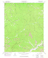
1967 Map of Lockwood
USGS Topo · Published 1977About this map
Lockwood and Lyonsville anchor the southern reaches of this West Virginia landscape, where the local economy and topography are defined by the extraction of natural resources and difficult mountain transit. Numerous Strip Mine operations and Gas Well sites are scattered throughout the hills, particularly around Peters Trail and the headwaters of Twentymile Creek. The infrastructure of the late 1960s and 1970s is visible in the presence of the Conrail line following the river valley and the remote settlements like Fola and Bickmore tucked into narrow hollows. Deeply carved drainages such as Cannel Coal Hollow and Leatherwood Creek illustrate the complex network of forks and branches that dictated the placement of small community centers like the Lick Fork Freewill Ch and the Otter Creek Sch.
Find a feature on this map
51 named features on this map. Tap any name to fly to it.
Don’t see what you’re looking for? This feature index may not catch every label — zoom into the map to look around manually.
Map Details
Editions of this 1967 Lockwood Map
2 editions found
Other maps of this area

1889 · Nicholas
USGS Topo · 1:125,000

1891 · Nicholas
USGS Topo · 1:125,000

1897 · Kanawha Falls
USGS Topo · 1:125,000

1900 · Kanawha Falls
USGS Topo · 1:125,000

1901 · Nicholas
USGS Topo · 1:125,000

1901 · Kanawha Falls
USGS Topo · 1:125,000

1908 · Clay
USGS Topo · 1:48,000

1908 · Fayetteville
USGS Topo · 1:48,000

1910 · Clay
USGS Topo · 1:62,500

1910 · Fayetteville
USGS Topo · 1:62,500