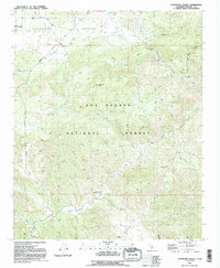
1991 Map of Lockwood Valley
USGS Topo · Published 1991About this map
Lockwood Valley serves as a high-altitude drainage basin within the Los Padres National Forest during the late twentieth century. The terrain is defined by a dense network of seasonal and perennial waterways, including the winding Amargosa Creek, Lockwood Creek, and Piru Creek. Resource extraction and land management are visible through various prospect sites and a borrow pit near Lockwood Valley Road, reflecting the ongoing utility of this mountainous region. Settlement is sparse, represented by managed recreation areas such as Halfmoon Campground and Snedden Campground. The geography transitions from the flat expanse of Mutau Flat to the prominent heights of Lockwood Peak, while Grade Valley provides a natural corridor through the surrounding peaks. This 1991 edition captures the area after several decades of forest management and early resource exploration.
Find a feature on this map
28 named features on this map. Tap any name to fly to it.
Don’t see what you’re looking for? This feature index may not catch every label — zoom into the map to look around manually.
Map Details
Editions of this 1991 Lockwood Valley Map
2 editions found
Other maps of this area

1903 · Mt. Pinos
USGS Topo · 1:125,000

1903 · Tejon
USGS Topo · 1:125,000

1942 · Frazier Mountain
USGS Topo · 1:24,000

1943 · Topatopa Mountains
USGS Topo · 1:24,000

1943 · San Guillermo
USGS Topo · 1:24,000

1943 · Sawmill Mountain
USGS Topo · 1:24,000

1943 · Cuddy Valley
USGS Topo · 1:24,000

1943 · Lockwood Valley
USGS Topo · 1:24,000

1943 · Lion Canyon
USGS Topo · 1:24,000
1943 · Devils Heart Peak
USGS Topo · 1:24,000