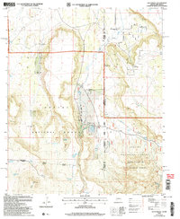
2005 Map of Loco Knoll
USGS Topo · Published 2006About this map
The Apache National Forest straddles the high-altitude border of Arizona and New Mexico, defined by the prominent Loco Knolls and the volcanic peak of Loco Knoll. This rugged plateau landscape is shaped by the headwaters of Coyote Creek and Canovas Creek, where water management for livestock is the primary mark of human activity. The presence of numerous engineered water features, including H-V Reservoir, Pratt Lake, and various stock tanks like Ditch Tank, indicates a long-standing ranching economy. Significant landmarks such as the H-V Ranch and its adjacent Landing Strip illustrate the isolation of this high-country territory. Industrial use is represented by the Cinder Pit, while several deep wells, including Simpson Well and Towser Well, highlight the critical importance of reliable water sources in this arid timberland.
Find a feature on this map
32 named features on this map. Tap any name to fly to it.
Don’t see what you’re looking for? This feature index may not catch every label — zoom into the map to look around manually.
Map Details
Editions of this 2005 Loco Knoll Map
This is the sole edition of this map. No revisions or reprints were ever made.
Other maps of this area

1886 · St Johns
USGS Topo · 1:250,000

1892 · St Johns
USGS Topo · 1:250,000

1915 · Reserve
USGS Topo · 1:125,000

1918 · Reserve
USGS Topo · 1:125,000

1922 · Nutrioso
USGS Topo · 1:125,000

1954 · Clifton
USGS Topo · 1:250,000

1954 · Saint Johns
USGS Topo · 1:250,000

1957 · Clifton
USGS Topo · 1:250,000

1957 · Saint Johns
USGS Topo · 1:250,000

1958 · Clifton
USGS Topo · 1:250,000