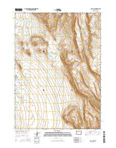
2014 Map of Loco Lake
USGS Topo · Published 2014About this map
Loco Lake lies at the heart of this high desert terrain in Lake County, situated within a landscape defined by significant elevation shifts and volcanic markers. The topographic detail captures the prominent ridge of Diablo Mtn and the distinct peak of Sharp Top, illustrating the arid hydrology of the region. Isolated water sources, such as Bailey Waterhole and S-Cut Waterhole, serve as vital landmarks for understanding historical land use and livestock movement in this portion of the Oregon outback. The mapping of Tenmile Ridge and Tenmile Butte provides a clear view of the north-south trending formations that dictate the drainage and transit patterns of the area.
Find a feature on this map
13 named features on this map. Tap any name to fly to it.
Don’t see what you’re looking for? This feature index may not catch every label — zoom into the map to look around manually.
Map Details
Editions of this 2014 Loco Lake Map
This is the sole edition of this map. No revisions or reprints were ever made.
Other maps of this area

1955 · Klamath Falls
USGS Topo · 1:250,000

1958 · Klamath Falls
USGS Topo · 1:250,000

1966 · Slide Mtn
USGS Topo · 1:24,000

1966 · Coglan Buttes
USGS Topo · 1:24,000

1966 · Paisley
USGS Topo · 1:24,000

1974 · Lake Abert
USGS Topo · 1:100,000

1985 · Sharp Top
USGS Topo · 1:24,000
1986 · Ana River
USGS Topo · 1:24,000
1986 · Loco Lake
USGS Topo · 1:24,000
1986 · Bull Lake
USGS Topo · 1:24,000