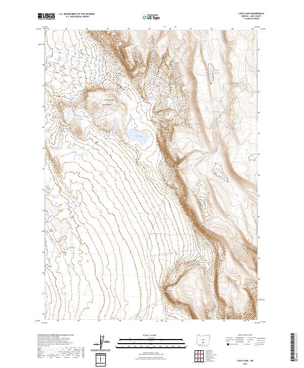
2023 Map of Loco Lake
USGS Topo · Published 2023About this map
Loco Lake sits at the center of this Lake County terrain, where the high desert landscape is defined by stark elevation changes and essential water catchments. The eastern portion of the map is dominated by a significant escarpment, punctuated by Fivemile Point, while the northern section features the prominent heights of Tenmile Ridge and Tenmile Butte. In an arid environment where water dictates the movement of both wildlife and industry, named features like Bailey Waterhole and South Gat Waterhole represent critical landmarks. The map illustrates a sparse, open territory organized by the Public Land Survey System, showing the intersections of Township 31 and 32 South across Ranges 18 and 19 East. This 2023 survey provides a clear view of the natural topography and remote landmarks that characterize this part of the Oregon interior.
Find a feature on this map
10 named features on this map. Tap any name to fly to it.
Don’t see what you’re looking for? This feature index may not catch every label — zoom into the map to look around manually.
Map Details
Editions of this 2023 Loco Lake Map
This is the sole edition of this map. No revisions or reprints were ever made.
Other maps of this area

1955 · Klamath Falls
USGS Topo · 1:250,000

1958 · Klamath Falls
USGS Topo · 1:250,000

1966 · Slide Mtn
USGS Topo · 1:24,000

1966 · Coglan Buttes
USGS Topo · 1:24,000

1966 · Paisley
USGS Topo · 1:24,000

1974 · Lake Abert
USGS Topo · 1:100,000

1985 · Sharp Top
USGS Topo · 1:24,000
1986 · Ana River
USGS Topo · 1:24,000
1986 · Loco Lake
USGS Topo · 1:24,000
1986 · Bull Lake
USGS Topo · 1:24,000