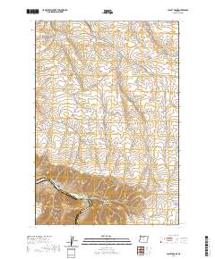
2020 Map of Locust Grove
USGS Topo · Published 2020About this map
Locust Grove sits within the high plateau country of North Central Oregon, where the landscape is defined by a dense network of drainages cutting toward the Deschutes River. This modern survey illustrates the rugged topography along the Sherman Co Wasco Co border, featuring prominent landforms like Gordon Ridge and the steep Rattlesnake Grade. The area's hydrology is marked by isolated water sources such as Sand Spring, Wingate Spring, and Jackass Spring, which historically supported the ranching and agricultural operations represented by names like Wheatacres RD and Goat Ranch LN. Along the river's edge, the Deschutes River Trail skirts the bank near Harris Island and Fall Canyon, providing a detailed look at the corridor's accessibility. Numerous deep-cut canyons, including Ferry Springs Canyon and Neece Canyon, showcase the geological erosion patterns typical of this dry, high-elevation region.
Find a feature on this map
42 named features on this map. Tap any name to fly to it.
Don’t see what you’re looking for? This feature index may not catch every label — zoom into the map to look around manually.
Map Details
Editions of this 2020 Locust Grove Map
This is the sole edition of this map. No revisions or reprints were ever made.
Other maps of this area

1953 · The Dalles
USGS Topo · 1:250,000

1956 · The Dalles
USGS Topo · 1:250,000

1957 · The Dalles
USGS Topo · 1:250,000

1957 · Wasco
USGS Topo · 1:62,500

1957 · Wishram
USGS Topo · 1:62,500

1962 · Erskine
USGS Topo · 1:24,000

1962 · Summit Ridge
USGS Topo · 1:24,000

1971 · Moro
USGS Topo · 1:24,000

1971 · Rufus
USGS Topo · 1:24,000
1971 · Wasco
USGS Topo · 1:24,000