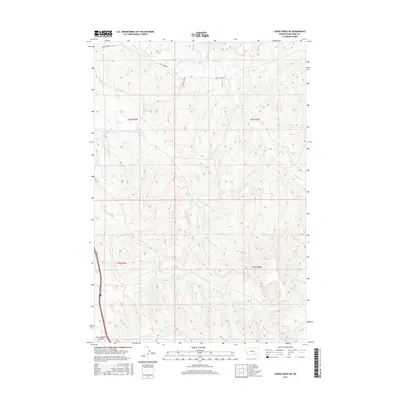
2017 Map of Lodge Grass NE
USGS Topo · Published 2017About this map
Little Bighorn Valley defines the western edge of this Montana landscape, where the terrain breaks into a complex system of drainages and coulees. This 2017 survey documents a high-plains environment deeply carved by water, with Reno Cr and its tributaries, including S Fork Reno Cr, flowing across the northern sections. Farther south, the watershed shifts toward Long Otter Cr, Shavings Cr, and Slaughter Cr. The presence of Reno Creek Rd and Reno Inlet Dt indicates the necessary infrastructure for navigating and managing water in this ranching country. The map provides a precise record of the township and range divisions, such as t4s r35e and t5s r36e, which organize the expansive rural tracts of Big Horn County.
Find a feature on this map
13 named features on this map. Tap any name to fly to it.
Don’t see what you’re looking for? This feature index may not catch every label — zoom into the map to look around manually.
Map Details
Editions of this 2017 Lodge Grass NE Map
This is the sole edition of this map. No revisions or reprints were ever made.
Other maps of this area

1894 · Rosebud
USGS Topo · 1:125,000

1901 · Rosebud
USGS Topo · 1:125,000

1954 · Hardin
USGS Topo · 1:250,000

1957 · Hardin
USGS Topo · 1:250,000

1958 · Hardin
USGS Topo · 1:250,000

1967 · Crow Agency SE
USGS Topo · 1:24,000

1967 · Lodge Grass NE
USGS Topo · 1:24,000

1967 · Wolf Mountain Lookout
USGS Topo · 1:24,000
1967 · Benteen
USGS Topo · 1:24,000
1967 · Crow Agency
USGS Topo · 1:24,000