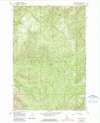
1966 Map of Lodge Point
USGS Topo · Published 1987About this map
Nez Perce National Forest dominates this interior Idaho landscape, where high ridgelines and deep drainage basins define the geography. Centered on Lodge Point and Lookout Butte, the area is characterized by a dense network of primitive transportation routes, including several labeled Pack Trails and a Jeep Trail that traverse the steep grades between creek beds. This 1966 survey, later photorevised in 1987, documents the complex hydrology of the region, featuring the headwaters of Tahoe Creek, Little Tinker Creek, and Swiftwater Creek. The southern portion of the sheet is marked by the winding course of the Middle Fork Clear Creek, a significant waterway that receives runoff from numerous named tributaries like Solo Creek and Goddard Creek. Notable landmarks such as Pine Knob and the isolated Browns Spring provide fixed points for navigating this backcountry terrain before modern road development altered the access patterns.
Find a feature on this map
19 named features on this map. Tap any name to fly to it.
Don’t see what you’re looking for? This feature index may not catch every label — zoom into the map to look around manually.
Map Details
Editions of this 1966 Lodge Point Map
2 editions found
Other maps of this area

1924 · Weippe
USGS Topo · 1:125,000

1931 · Buffalo Hump
USGS Topo · 1:125,000

1934 · Buffalo Hump
USGS Topo · 1:125,000

1956 · Elk City
USGS Topo · 1:250,000

1956 · Hamilton
USGS Topo · 1:250,000

1959 · Hamilton
USGS Topo · 1:250,000

1960 · Elk City
USGS Topo · 1:250,000

1960 · Hamilton
USGS Topo · 1:250,000

1962 · Iron Mtn
USGS Topo · 1:24,000

1962 · Pilot Knob
USGS Topo · 1:24,000