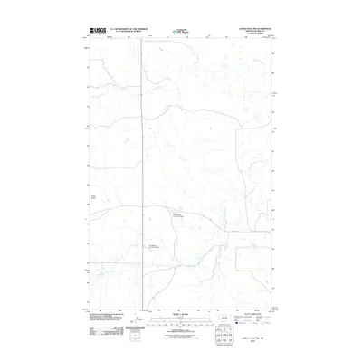
2011 Map of Lodge Pole NW
USGS Topo · Published 2011About this map
Peoples Creek and its various tributaries define this section of north-central Montana on the Fort Belknap Reservation. This landscape is characterized by a high-desert drainage system where the South Fork Peoples Creek, Lodge Pole Creek, and Jim Brown Creek converge across an area of significant elevation changes. To the west, the prominent formation of Three Buttes stands as a landmark overlooking the rolling plains. Water management for the region is evidenced by the presence of the Fort Belknap Number 34 Dam and Fort Belknap Number 35 Dam, which harness the intermittent flows of the local coulees and creeks. Access to this remote territory is primarily facilitated via 3 Buttes Rd, providing a look at the infrastructure supporting the local ranching and tribal lands during the early 21st century.
Find a feature on this map
8 named features on this map. Tap any name to fly to it.
Don’t see what you’re looking for? This feature index may not catch every label — zoom into the map to look around manually.
Map Details
Editions of this 2011 Lodge Pole NW Map
This is the sole edition of this map. No revisions or reprints were ever made.
Other maps of this area

1953 · Havre
USGS Topo · 1:250,000

1957 · Havre
USGS Topo · 1:250,000

1958 · Havre
USGS Topo · 1:250,000
1971 · Fort Belknap Agency SE
USGS Topo · 1:24,000

1971 · Lodge Pole NW
USGS Topo · 1:24,000

1971 · Lodge Pole NE
USGS Topo · 1:24,000
1971 · Stiffarm Coulee
USGS Topo · 1:24,000
1971 · Lake Seventeen NE
USGS Topo · 1:24,000
1971 · Lodge Pole
USGS Topo · 1:24,000
1971 · Bigby Lake
USGS Topo · 1:24,000