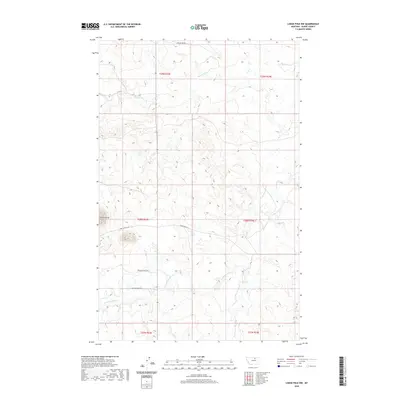
2020 Map of Lodge Pole NW
USGS Topo · Published 2020About this map
Three Buttes dominates the landscape of this region in Blaine County, rising above a network of drainages that define the local topography. This 2020 survey reveals a land shaped by the winding courses of Peoples Cr and the S Fork Peoples Cr, which flow through the northern and central sections of the quadrangle. The map documents a sparse but significant road network, including family-named routes like Jack Quisno Dr, Bertha Snow Rd, and Foxy Filesteel Dr, providing vital context for local history and genealogy in the Agency District. In the southeast, Lodge Pole Cr and Jim Brown Cr carve through the terrain, illustrating the drainage patterns that have likely influenced land use and movement through this part of the Fort Belknap Reservation area for generations.
Find a feature on this map
16 named features on this map. Tap any name to fly to it.
Don’t see what you’re looking for? This feature index may not catch every label — zoom into the map to look around manually.
Map Details
Editions of this 2020 Lodge Pole NW Map
This is the sole edition of this map. No revisions or reprints were ever made.
Other maps of this area

1953 · Havre
USGS Topo · 1:250,000

1957 · Havre
USGS Topo · 1:250,000

1958 · Havre
USGS Topo · 1:250,000
1971 · Fort Belknap Agency SE
USGS Topo · 1:24,000

1971 · Lodge Pole NW
USGS Topo · 1:24,000

1971 · Lodge Pole NE
USGS Topo · 1:24,000
1971 · Stiffarm Coulee
USGS Topo · 1:24,000
1971 · Lake Seventeen NE
USGS Topo · 1:24,000
1971 · Lodge Pole
USGS Topo · 1:24,000
1971 · Bigby Lake
USGS Topo · 1:24,000