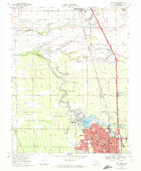
1968 Map of Lodi North
USGS Topo · Published 1972About this map
The Mokelumne River snakes through the heart of this landscape, its winding course defining the boundary between the expanding city of Lodi and the agricultural lands to the north. In this era, Lodi is a bustling hub for the Central Valley's viticulture and industry, shown with a dense street grid featuring St Annes Academy, Lawrence Sch, and the Grape Festival Grounds. The map illustrates a transition from urban development to rural vineyard country, where the Southern Pacific and Western Pacific railroads facilitate the movement of goods from small loading points like Acampo and Urgon.
Find a feature on this map
99 named features on this map. Tap any name to fly to it.
Don’t see what you’re looking for? This feature index may not catch every label — zoom into the map to look around manually.
Map Details
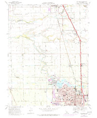
Editions of this 1968 Lodi North Map
2 editions found
Other maps of this area

1894 · Lodi
USGS Topo · 1:125,000

1908 · Waterloo
USGS Topo · 1:31,680

1908 · Lockeford
USGS Topo · 1:31,680

1909 · Clay
USGS Topo · 1:31,680

1910 · New Hope
USGS Topo · 1:31,680

1910 · Castle
USGS Topo · 1:31,680

1910 · Woodbridge
USGS Topo · 1:31,680

1910 · Bruceville
USGS Topo · 1:31,680

1910 · Headreach
USGS Topo · 1:31,680

1910 · Galt
USGS Topo · 1:31,680