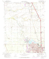
1968 Map of Lodi North
USGS Topo · Published 1977About this map
The Mokelumne River winds through this Central Valley landscape, defining the transition from the agricultural lands of northern San Joaquin County to the urban fringes of Lodi. This 1968 survey, updated in 1976, captures the northward expansion of the city towards the water, notably around Lodi Municipal Lake Park. To the north, the legacy of Spanish land grants is preserved in the name San Joaquin De Los Moquelumnes, while the Southern Pacific railroad corridor tethers the small agricultural hubs of Acampo, Collierville, and Galt together. The map highlights a community anchored by local institutions, from the Grape Festival Buildings reflecting the region's viticulture to numerous neighborhood schools like Needham Sch and Reese Sch. Smaller settlements such as Urgon and Woodbridge sit alongside complex irrigation networks including the West Main Canal.
Find a feature on this map
70 named features on this map. Tap any name to fly to it.
Don’t see what you’re looking for? This feature index may not catch every label — zoom into the map to look around manually.
Map Details
Editions of this 1968 Lodi North Map
2 editions found
Other maps of this area

1894 · Lodi
USGS Topo · 1:125,000

1908 · Waterloo
USGS Topo · 1:31,680

1908 · Lockeford
USGS Topo · 1:31,680

1909 · Clay
USGS Topo · 1:31,680

1910 · New Hope
USGS Topo · 1:31,680

1910 · Castle
USGS Topo · 1:31,680

1910 · Woodbridge
USGS Topo · 1:31,680

1910 · Bruceville
USGS Topo · 1:31,680

1910 · Headreach
USGS Topo · 1:31,680

1910 · Galt
USGS Topo · 1:31,680