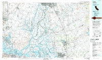
1993 Map of Lodi
USGS Topo · Published 1994About this map
The Mokelumne River and San Joaquin River converge in a complex network of waterways that defines this Central Valley landscape in the early 1990s. This survey illustrates the intricate irrigation and reclamation history of the California Delta, featuring dozens of named tracts and islands such as Staten Island, Webb Tract, and Bouldin Island. To the west, the Montezuma Hills rise above the confluence near Antioch and Pittsburg, while the northern portion of the sheet captures the urban expansion of Sacramento and Elk Grove.
Find a feature on this map
129 named features on this map. Tap any name to fly to it.
Don’t see what you’re looking for? This feature index may not catch every label — zoom into the map to look around manually.
Map Details
Editions of this 1993 Lodi Map
2 editions found
Other maps of this area

1889 · Jackson
USGS Topo · 1:125,000

1891 · Sacramento
USGS Topo · 1:125,000

1891 · Placerville
USGS Topo · 1:125,000

1892 · Jackson
USGS Topo · 1:125,000

1892 · Sacramento
USGS Topo · 1:125,000

1892 · Placerville
USGS Topo · 1:125,000

1893 · Placerville
USGS Topo · 1:125,000

1893 · Sacramento
USGS Topo · 1:125,000

1894 · Lodi
USGS Topo · 1:125,000

1896 · Carquinez Strait
USGS Topo · 1:62,500