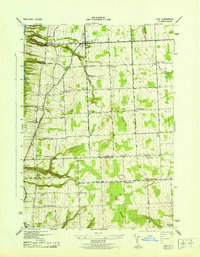
1943 Map of Lodi
USGS Topo · Published 1943About this map
Seneca Lake defines the western edge of this 1943 survey, where the Lehigh Valley Railroad skirts the shore near Caywood and Lodi Sta. The interior landscape reveals a network of rural school districts, including School No 11 and the Round Schoolhouse, which served the farming families of the Finger Lakes region during the early 1940s. The terrain rises from the lake towards prominent heights like Butcher Hill and the ridge known as Backbone, dividing the drainage between Mill Creek and Breakneck Creek. Small hamlets and crossroads like Lodi Center, Townsendville, and Bumpus Corners are interconnected by historically significant routes such as Trumansburg Road. The map also captures several family-named burial grounds, such as Cronk Cem and Valois Cem, providing valuable spatial context for local genealogical research into the area's established farming communities.
Find a feature on this map
34 named features on this map. Tap any name to fly to it.
Don’t see what you’re looking for? This feature index may not catch every label — zoom into the map to look around manually.
Map Details
Editions of this 1943 Lodi Map
This is the sole edition of this map. No revisions or reprints were ever made.
Other maps of this area

1893 · Ithaca
USGS Topo · 1:62,500

1895 · Ithaca
USGS Topo · 1:62,500

1898 · Watkins Glen
USGS Topo · 1:62,500

1901 · Watkins
USGS Topo · 1:62,500

1902 · Genoa
USGS Topo · 1:62,500

1902 · Ovid
USGS Topo · 1:62,500

1905 · Watkins Glen
USGS Topo · 1:125,000

1942 · Ovid
USGS Topo · 1:31,680

1942 · Dundee
USGS Topo · 1:24,000

1942 · Lodi
USGS Topo · 1:24,000