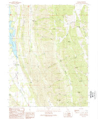
1989 Map of Lodoga
USGS Topo · Published 1989About this map
East Park Reservoir defines the western edge of this Colusa County landscape, where the settlement of Lodoga sits at the foot of Clark Ridge. The geography is characterized by a dense network of canyons and peaks, including the prominent Lodoga Peak and Black Mountain. Evidence of early travel and land use is visible through named routes like the Little Antelope Grade and the small cemetery near the town site. The terrain transitions from the reservoir's shoreline into the elevated reaches of High Valley and Grapevine Pass. Numerous water sources, such as Scotties Spring and Indian Creek, highlight the natural drainage patterns flowing through Grapevine Canyon and Scotties Canyon, providing a detailed look at the rural topography of the California Coast Ranges in the late 1980s.
Find a feature on this map
36 named features on this map. Tap any name to fly to it.
Don’t see what you’re looking for? This feature index may not catch every label — zoom into the map to look around manually.
Map Details
Editions of this 1989 Lodoga Map
2 editions found
Other maps of this area

1904 · Logan Creek
USGS Topo · 1:24,000

1904 · Sites
USGS Topo · 1:24,000

1905 · Fairview
USGS Topo · 1:24,000

1917 · Sites
USGS Topo · 1:31,680

1918 · Logan Creek
USGS Topo · 1:31,680

1920 · Venado
USGS Topo · 1:62,500

1924 · Bartlett Springs
USGS Topo · 1:62,500

1942 · Bartlett Springs
USGS Topo · 1:62,500

1943 · Lodoga
USGS Topo · 1:62,500

1944 · Bartlett Springs
USGS Topo · 1:62,500