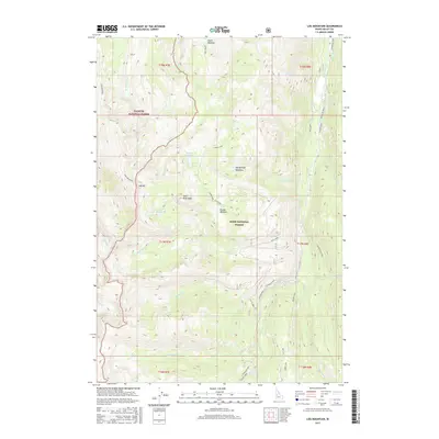
2017 Map of Log Mountain
USGS Topo · Published 2017About this map
Log Mountain serves as a prominent high point in this 2017 survey of the high-elevation backcountry where the Payette National Forest and Boise National Forest converge. This area is defined by its complex drainage network, where Johnson Creek flows through the eastern corridor and numerous smaller tributaries like Caton Cr and Ditch Cr carve through the steep terrain. The presence of several distinct meadows, including Caton Meadow, Round Meadow, and Wardenhoff Meadows, suggests important openings in the heavy timber that have historically served as landmarks or grazing points. Notable peaks such as Shell Rock Peak and Thunder Mountain provide orientation for those navigating the roadless portions of Valley County. For those tracing the geography of the Salmon River Mountains, the map highlights significant water features like Caton Lake, Rainbow Lake, and the turbulent Whitehorse Rapids.
Find a feature on this map
40 named features on this map. Tap any name to fly to it.
Don’t see what you’re looking for? This feature index may not catch every label — zoom into the map to look around manually.
Map Details
Editions of this 2017 Log Mountain Map
This is the sole edition of this map. No revisions or reprints were ever made.
Other maps of this area

1937 · Yellow Pine
USGS Topo · 1:48,000

1943 · Yellow Pine
USGS Topo · 1:62,500

1954 · Warm Lake
USGS Topo · 1:62,500

1957 · Challis
USGS Topo · 1:250,000

1960 · Challis
USGS Topo · 1:250,000

1961 · Chinook Mtn
USGS Topo · 1:62,500

1963 · Challis
USGS Topo · 1:250,000
1973 · Chilcoot Peak
USGS Topo · 1:24,000
1973 · Yellow Pine
USGS Topo · 1:24,000

1973 · White Rock Peak
USGS Topo · 1:24,000