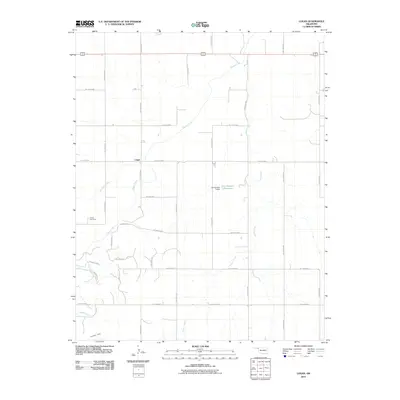
2010 Map of Logan
USGS Topo · Published 2010About this map
Logan sits at the center of this Oklahoma landscape, defined by a grid of rural roads and a network of creeks moving across the High Plains. The settlement pattern is anchored by the Kiowa Cemetery, located west of the primary north-south route of Hollow N1560. Water management is a visible priority in this arid region, as evidenced by the Jett Number 3 Dam and Jett Number 3 Reservoir situated along the eastern drainage of Indian Creek. The terrain is marked by distinctive rises like Indian Hill in the southwest, while several seasonal waterways, including Don Jose Creek and Coon Creek, carve shallow paths through the flatlands. This survey captures the sparse, structured organization of Beaver County at the start of the 21st century, where large-scale agriculture and land division are mapped out through an extensive numbered road system like Hollow E0330 and Hollow E0340.
Find a feature on this map
29 named features on this map. Tap any name to fly to it.
Don’t see what you’re looking for? This feature index may not catch every label — zoom into the map to look around manually.
Map Details
Editions of this 2010 Logan Map
This is the sole edition of this map. No revisions or reprints were ever made.
Other maps of this area

1954 · Perryton
USGS Topo · 1:250,000

1958 · Perryton
USGS Topo · 1:250,000

1971 · Clear Lake
USGS Topo · 1:24,000

1971 · Clear Lake SE
USGS Topo · 1:24,000

1971 · Logan
USGS Topo · 1:24,000

1971 · Logan NW
USGS Topo · 1:24,000

1971 · Logan NE
USGS Topo · 1:24,000

1971 · Slapout
USGS Topo · 1:24,000
1972 · Magoun
USGS Topo · 1:24,000

1972 · Follett
USGS Topo · 1:24,000