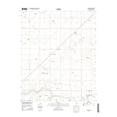
2013 Map of Logan NE
USGS Topo · Published 2013About this map
The Canadian River meanders through the southern portion of this landscape, carving a low valley through the high plains of Quay County. This ranching territory is defined by its extensive network of water sources, from the Shallow Well Draw to numerous named family water points like South Bunk Clay Well, Jones Well, and the Clay Windmill. The map details a sparsely populated area where large property holdings predominate, including the Sand Springs Ranch, Rodewald Ranch, and the central Bunk Clay Place. These landmarks, along with a solitary Gravel Pit and a web of rural routes like Quay Road 83 and Quay Road R, illustrate the infrastructure required to maintain life and livestock in this semi-arid environment. The transition from the flat plains to the river breaks near Hadden Ranch provides a clear view of the local drainage patterns that have historically shaped land use in the region.
Find a feature on this map
45 named features on this map. Tap any name to fly to it.
Don’t see what you’re looking for? This feature index may not catch every label — zoom into the map to look around manually.
Map Details
Editions of this 2013 Logan NE Map
This is the sole edition of this map. No revisions or reprints were ever made.
Other maps of this area

1954 · Tucumcari
USGS Topo · 1:250,000

1958 · Tucumcari
USGS Topo · 1:250,000

1962 · Logan
USGS Topo · 1:62,500

1966 · Lockney
USGS Topo · 1:24,000

1966 · Mc Carty Ranch
USGS Topo · 1:24,000

1968 · Blue Hole
USGS Topo · 1:24,000

1968 · Cammak Camp
USGS Topo · 1:24,000

1971 · Obar
USGS Topo · 1:24,000
1989 · Tuscocoillo Canyon
USGS Topo · 1:24,000
1989 · Logan South
USGS Topo · 1:24,000