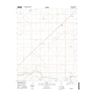
2017 Map of Logan NE
USGS Topo · Published 2017About this map
The Canadian River winds through the southern reaches of this landscape in eastern Quay County, carving a distinct corridor through the high plains. In this arid environment, the presence of named water features like Sand Springs and Shallow Well Draw highlights the vital importance of reliable water sources for local ranching operations. The terrain is organized by a systematic grid of ranch roads, including Quay Road 85 and Quay Road T, which provide access to remote pastures and section lines. This survey captures the sparse, functional layout of the New Mexico cattle country, where the intersection of the river's natural course and the rigid Public Land Survey System defines the region's human geography. Collectors and researchers can trace the modern road network against the historical township and range boundaries of t14n r34e and surrounding sections.
Find a feature on this map
15 named features on this map. Tap any name to fly to it.
Don’t see what you’re looking for? This feature index may not catch every label — zoom into the map to look around manually.
Map Details
Editions of this 2017 Logan NE Map
This is the sole edition of this map. No revisions or reprints were ever made.
Other maps of this area

1954 · Tucumcari
USGS Topo · 1:250,000

1958 · Tucumcari
USGS Topo · 1:250,000

1962 · Logan
USGS Topo · 1:62,500

1966 · Lockney
USGS Topo · 1:24,000

1966 · Mc Carty Ranch
USGS Topo · 1:24,000

1968 · Blue Hole
USGS Topo · 1:24,000

1968 · Cammak Camp
USGS Topo · 1:24,000

1971 · Obar
USGS Topo · 1:24,000
1989 · Tuscocoillo Canyon
USGS Topo · 1:24,000
1989 · Logan South
USGS Topo · 1:24,000