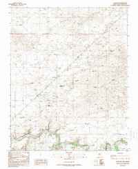
1989 Map of Logan NE
USGS Topo · Published 1989About this map
The Canadian River cuts through the southern portion of this landscape in Quay County, its winding course defining the local geography. This high plains region is dominated by an extensive network of water infrastructure, essential for ranching and settlement in an arid environment. Named wells like Garrison Well, Barnes Well, and Litton Well are scattered across the terrain, alongside family-named landmarks such as Shoenail Ranch. The map reveals a land utilized for its natural resources, with a Gravel Pit and Clay Pit located near the riverbank. Geologic and water features like Sand Springs and the Blue Hole provide distinct landmarks, while various windmills, such as Woods Windmill and Clay Windmill, emphasize the reliance on groundwater to sustain the ranching operations that have shaped this part of New Mexico.
Find a feature on this map
32 named features on this map. Tap any name to fly to it.
Don’t see what you’re looking for? This feature index may not catch every label — zoom into the map to look around manually.
Map Details
Editions of this 1989 Logan NE Map
This is the sole edition of this map. No revisions or reprints were ever made.
Other maps of this area

1954 · Tucumcari
USGS Topo · 1:250,000

1958 · Tucumcari
USGS Topo · 1:250,000

1962 · Logan
USGS Topo · 1:62,500

1966 · Lockney
USGS Topo · 1:24,000

1966 · Mc Carty Ranch
USGS Topo · 1:24,000

1968 · Blue Hole
USGS Topo · 1:24,000

1968 · Cammak Camp
USGS Topo · 1:24,000

1971 · Obar
USGS Topo · 1:24,000
1989 · Tuscocoillo Canyon
USGS Topo · 1:24,000
1989 · Logan South
USGS Topo · 1:24,000