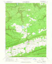
1965 Map of Loganton
USGS Topo · Published 1966About this map
Loganton sits at the heart of Sugar Valley, where agricultural clearings are sharply defined by the steep, forested walls of Bald Eagle Mountain and Big Mountain. This 1965 survey shows a rural landscape anchored by small crossroads settlements like Schracktown, Booneville, and Greenburr, connected by the winding course of Fishing Creek. The map records the local infrastructure of the mid-1960s, including the Sugar Valley Area Sch and several historic burial grounds such as the Old Schracktown Cem.
Find a feature on this map
65 named features on this map. Tap any name to fly to it.
Don’t see what you’re looking for? This feature index may not catch every label — zoom into the map to look around manually.
Map Details
Editions of this 1965 Loganton Map
Other maps of this area

1921 · Williamsport
USGS Topo · 1:48,000

1921 · Lock Haven
USGS Topo · 1:62,500

1923 · Lock Haven
USGS Topo · 1:62,500

1923 · Williamsport
USGS Topo · 1:62,500

1937 · Millheim
USGS Topo · 1:48,000

1938 · Mifflinburg
USGS Topo · 1:48,000

1941 · Millheim
USGS Topo · 1:62,500

1943 · Mifflinburg
USGS Topo · 1:62,500

1944 · Williamsport
USGS Topo · 1:62,500

1944 · Lock Haven
USGS Topo · 1:62,500
Featured Places
- Loganton, PA
- Logan Township, PA
- Greenburr, Logan Township
- Booneville, Logan Township
- Crawford Township, PA