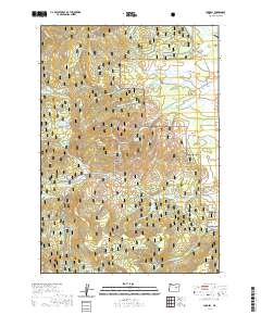
2020 Map of Logdell
USGS Topo · Published 2020About this map
Malheur National Forest dominates this high-altitude landscape in Grant County, defined by a complex drainage network where the Silvies River and its numerous tributaries, such as Dipping Vat Cr and Eddington Cr, carve through the terrain. The small community of Logdell sits near the eastern edge of the map, serving as a focal point for the surrounding cattle country and timber lands. Historical land use is evident in the density of named water sources like Station Spring, Ninety Six Spring, and Wickiup Spring, which have long supported ranching and forest management.
Find a feature on this map
40 named features on this map. Tap any name to fly to it.
Don’t see what you’re looking for? This feature index may not catch every label — zoom into the map to look around manually.
Map Details
Editions of this 2020 Logdell Map
This is the sole edition of this map. No revisions or reprints were ever made.
Other maps of this area

1940 · Mount Vernon
USGS Topo · 1:62,500

1940 · Aldrich Mtn.
USGS Topo · 1:62,500

1943 · Aldrich Mtn.
USGS Topo · 1:62,500

1943 · Mount Vernon
USGS Topo · 1:62,500

1955 · Canyon City
USGS Topo · 1:250,000

1959 · Canyon City
USGS Topo · 1:250,000

1961 · Logdell
USGS Topo · 1:62,500

1961 · Izee
USGS Topo · 1:62,500

1972 · Big Weasel Sprs
USGS Topo · 1:24,000
1972 · Mc Clellan Mtn
USGS Topo · 1:24,000