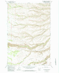
1965 Map of Logy Creek Falls
USGS Topo · Published 1983About this map
Logy Creek Falls highlights a landscape of intricate drainage systems in Yakima County as they appeared in the mid-1960s. The terrain is defined by a dense network of seasonal and perennial waterways including Lousy Creek, Third Creek, and Oak Creek flowing through the central and northern sections. The presence of Tannawasha Pasture and the intricate fencing indicated by fine dashed lines suggests an active ranching or grazing economy typical of the region's higher elevations. Transport across this topography was facilitated by a sparse network of unpaved routes, most notably the Dry Creek Elbow Road and various jeep trails. Notable landmarks like Bergie Springs and the steep descent of Logy Canyon offer specific points of interest for those tracing the historical geography of this section of Washington.
Find a feature on this map
24 named features on this map. Tap any name to fly to it.
Don’t see what you’re looking for? This feature index may not catch every label — zoom into the map to look around manually.
Map Details
Editions of this 1965 Logy Creek Falls Map
2 editions found
Other maps of this area

1937 · White Swan
USGS Topo · 1:125,000

1950 · Yakima
USGS Topo · 1:250,000

1958 · Toppenish Mtn.
USGS Topo · 1:24,000

1958 · Fort Simcoe
USGS Topo · 1:24,000

1958 · Fort Simcoe
USGS Topo · 1:62,500

1958 · Harrah SE
USGS Topo · 1:24,000

1958 · Yakima
USGS Topo · 1:250,000

1961 · Yakima
USGS Topo · 1:250,000
1965 · Kusshi Creek
USGS Topo · 1:24,000
1965 · Logy Creek
USGS Topo · 1:62,500