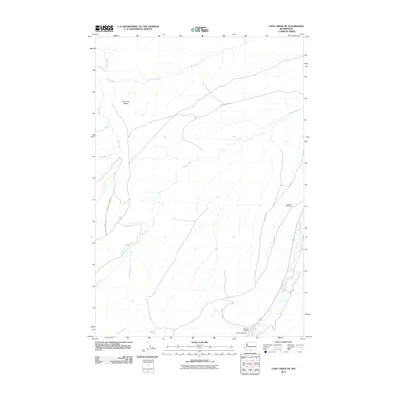
2011 Map of Logy Creek NE
USGS Topo · Published 2011About this map
Logy Creek and Satus Creek define the drainage of this Yakima County landscape, which is marked by numerous ephemeral waterways and distinct geological features. The terrain includes the prominent Dry Creek Elbow and the depths of Lizzy Canyon in the southern portion of the quadrangle. Local heritage is grounded in the presence of Toweatmy Cemetery and Sampson Cemetery, which reflect the long-standing community presence on this land. The map details a network of BIA roads, such as Bia 160 RD and Bia 216 RD, providing access through a territory punctuated by humorously and descriptively named streams like Lousy Creek, Knockout Creek, and Fortyday Creek. This 2011 survey documents the land as it appeared in the early 21st century, showing a mix of traditional locations and modern road designations.
Find a feature on this map
18 named features on this map. Tap any name to fly to it.
Don’t see what you’re looking for? This feature index may not catch every label — zoom into the map to look around manually.
Map Details
Editions of this 2011 Logy Creek NE Map
This is the sole edition of this map. No revisions or reprints were ever made.
Other maps of this area

1910 · Zillah
USGS Topo · 1:125,000

1937 · White Swan
USGS Topo · 1:125,000

1950 · Yakima
USGS Topo · 1:250,000

1958 · Toppenish SW
USGS Topo · 1:24,000

1958 · Toppenish Mtn.
USGS Topo · 1:24,000

1958 · Harrah SE
USGS Topo · 1:24,000

1958 · Yakima
USGS Topo · 1:250,000

1961 · Yakima
USGS Topo · 1:250,000
1965 · Kusshi Creek
USGS Topo · 1:24,000
1965 · Logy Creek
USGS Topo · 1:62,500