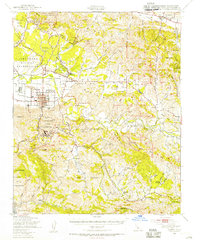
1947 Map of Lompoc
USGS Topo · Published 1956About this map
The Santa Ynez River carves through the heart of this coastal valley, separating the Purisima Hills from the Santa Rita Hills. In the late 1940s, the landscape around Lompoc reflects a deep Spanish colonial heritage alongside mid-century military and industrial growth. Significant historical sites including Mission La Purisima and La Mission Vieja De La Purisima are clearly documented, with the former preserved within Mission La Purisima State Park. To the west, the Camp Cooke Military Reservation dominates the coastal terrace, while the town's economic activity is highlighted by the Southern Pacific rail line and large Diatomaceous Earth Quarries located south of the river. Rural life is evidenced by the presence of the Jalama Sch and small settlements like Acorn and Jalama.
Find a feature on this map
67 named features on this map. Tap any name to fly to it.
Don’t see what you’re looking for? This feature index may not catch every label — zoom into the map to look around manually.
Map Details
Editions of this 1947 Lompoc Map
2 editions found
Other maps of this area

1905 · Guadalupe
USGS Topo · 1:125,000

1905 · Lompoc
USGS Topo · 1:125,000

1942 · Point Arguello
USGS Topo · 1:62,500

1942 · Guadalupe
USGS Topo · 1:125,000

1942 · Lompoc
USGS Topo · 1:125,000

1942 · Lompoc
USGS Topo · 1:62,500

1942 · Pt. Conception
USGS Topo · 1:62,500

1942 · Santa Maria
USGS Topo · 1:62,500

1942 · Gaviota
USGS Topo · 1:62,500

1942 · Point Sal
USGS Topo · 1:62,500