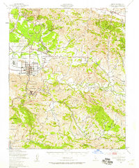
1947 Map of Lompoc
USGS Topo · Published 1959About this map
Camp Cooke Military Reservation dominates the western landscape of this mid-century survey, illustrating the significant military footprint in Santa Barbara County. The Lompoc townsite is clearly defined by its grid, served by the Southern Pacific railroad and a nearby Municipal Airport. The map captures a transitional era for the region's heritage, marking the Mission La Purisima State Park and Mission La Purisima alongside the industrial activity at the Diatomaceous Earth Quarries in the hills to the south.
Find a feature on this map
63 named features on this map. Tap any name to fly to it.
Don’t see what you’re looking for? This feature index may not catch every label — zoom into the map to look around manually.
Map Details
Editions of this 1947 Lompoc Map
2 editions found
Other maps of this area

1905 · Guadalupe
USGS Topo · 1:125,000

1905 · Lompoc
USGS Topo · 1:125,000

1942 · Point Arguello
USGS Topo · 1:62,500

1942 · Guadalupe
USGS Topo · 1:125,000

1942 · Lompoc
USGS Topo · 1:125,000

1942 · Lompoc
USGS Topo · 1:62,500

1942 · Pt. Conception
USGS Topo · 1:62,500

1942 · Santa Maria
USGS Topo · 1:62,500

1942 · Gaviota
USGS Topo · 1:62,500

1942 · Point Sal
USGS Topo · 1:62,500