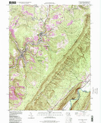
1998 Map of Lonaconing
USGS Topo · Published 1999About this map
Georges Creek carves a deep path through this Allegany County landscape, serving as the historical spine for a string of industrial coal settlements. Communities like Lonaconing, Midland, and Borden Shaft follow the narrow valley floor, while higher elevations are defined by the expansive Dans Mountain range and the Dans Mountain State Wildlife Management Area. The map documents the region's industrial legacy through several strip mines and railroad infrastructure including the Klondike (Lord Sta) and Carlos Junction.
Find a feature on this map
51 named features on this map. Tap any name to fly to it.
Don’t see what you’re looking for? This feature index may not catch every label — zoom into the map to look around manually.
Map Details
Editions of this 1998 Lonaconing Map
This is the sole edition of this map. No revisions or reprints were ever made.
Other maps of this area

1891 · Romney
USGS Topo · 1:125,000

1895 · Piedmont
USGS Topo · 1:125,000

1898 · Frostburg
USGS Topo · 1:62,500

1899 · Grantsville
USGS Topo · 1:62,500

1901 · Frostburg
USGS Topo · 1:62,500

1904 · Grantsville
USGS Topo · 1:62,500

1908 · Frostburg
USGS Topo · 1:62,500

1919 · Elk Garden
USGS Topo · 1:48,000

1920 · Elk Garden
USGS Topo · 1:48,000

1920 · Keyser
USGS Topo · 1:62,500