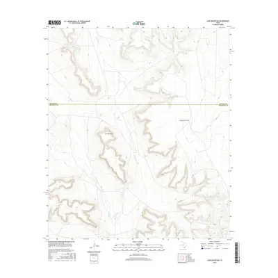
2016 Map of Lone Mountain
USGS Topo · Published 2016About this map
Lone Mountain stands as a prominent topographical landmark in this high-plains landscape of Crockett and Reagan Counties. The terrain is defined by a series of dramatic drainages and mesas, including the wide Schneemann Draw and the winding course of Noelke Cr. Settlement patterns here reflect the arid ranching economy of West Texas, where water management is critical, as evidenced by the Sugar Bowl Tank near the northern boundary. While the landscape is sparsely populated, the presence of Co Rd 208 and various unnumbered ranch roads provide access through the deep canyons and across the plateaus. This map offers a detailed view of the natural hydrology and elevation changes along Live Oak Cr, showing how the land dictated movement and utility in this remote region.
Find a feature on this map
8 named features on this map. Tap any name to fly to it.
Don’t see what you’re looking for? This feature index may not catch every label — zoom into the map to look around manually.
Map Details
Editions of this 2016 Lone Mountain Map
This is the sole edition of this map. No revisions or reprints were ever made.
Other maps of this area

1928 · Rankin
USGS Topo · 1:125,000

1929 · Sheffield
USGS Topo · 1:125,000

1954 · Sonora
USGS Topo · 1:250,000

1954 · San Angelo
USGS Topo · 1:250,000

1958 · Sonora
USGS Topo · 1:250,000

1958 · San Angelo
USGS Topo · 1:250,000

1965 · San Angelo
USGS Topo · 1:250,000

1967 · Owens Creek NE
USGS Topo · 1:24,000

1967 · Twelvemile Camp
USGS Topo · 1:24,000
1967 · Owens Creek NW
USGS Topo · 1:24,000