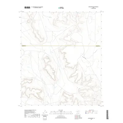
2019 Map of Lone Mountain
USGS Topo · Published 2019About this map
Lone Mtn rises above the arid landscape of the Edwards Plateau along the county line shared by Reagan and Crockett counties. This high-desert terrain is defined by the intermittent drainage of Noelke Cr and Live Oak Cr, which cut deep paths through the mesa-topped hills. Historically significant water sources like Grierson Springs and constructed catchments such as Sugar Bowl Tank highlight the critical importance of water management in this cattle-ranching region. The map reveals a sparse network of ranch roads including Co RD 208 and names local topographical landmarks like Schneemann Draw, reflecting the enduring land use patterns of the Trans-Pecos ranching frontier.
Find a feature on this map
9 named features on this map. Tap any name to fly to it.
Don’t see what you’re looking for? This feature index may not catch every label — zoom into the map to look around manually.
Map Details
Editions of this 2019 Lone Mountain Map
This is the sole edition of this map. No revisions or reprints were ever made.
Other maps of this area

1928 · Rankin
USGS Topo · 1:125,000

1929 · Sheffield
USGS Topo · 1:125,000

1954 · Sonora
USGS Topo · 1:250,000

1954 · San Angelo
USGS Topo · 1:250,000

1958 · Sonora
USGS Topo · 1:250,000

1958 · San Angelo
USGS Topo · 1:250,000

1965 · San Angelo
USGS Topo · 1:250,000

1967 · Owens Creek NE
USGS Topo · 1:24,000

1967 · Twelvemile Camp
USGS Topo · 1:24,000
1967 · Owens Creek NW
USGS Topo · 1:24,000