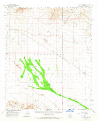
1961 Map of Lone Mountain
USGS Topo · Published 1967About this map
Mining operations and remote desert outposts characterize this arid landscape between the Harcuahala Mts and the Big Horn Mountains in the early 1960s. The northern reaches are dotted with historical extraction sites like the Socorro Mine, Alaska Mine, and Lions Den Mine, illustrating the intense prospecting effort in this pocket of Arizona. At the center of the sheet, the expansive Harquahala Plain transitions into Adobe Flats, where survival relied on a network of isolated water sources such as Government Well and Lone Mountain Well. Transportation through this territory is defined by the Buckeye Salome Road and various jeep trails, which connect the desert floor to the foothills of the Eagletail Mts. The presence of a Pipeline and scattered Ruins speaks to the region's industrial utility and sporadic human habitation across the Yuma and Maricopa county lines.
Find a feature on this map
36 named features on this map. Tap any name to fly to it.
Don’t see what you’re looking for? This feature index may not catch every label — zoom into the map to look around manually.
Map Details
Editions of this 1961 Lone Mountain Map
2 editions found
Other maps of this area

1942 · Vicksburg
USGS Topo · 1:250,000

1954 · Phoenix
USGS Topo · 1:250,000

1957 · Phoenix
USGS Topo · 1:250,000

1958 · Phoenix
USGS Topo · 1:250,000

1960 · Phoenix
USGS Topo · 1:250,000

1961 · Salome
USGS Topo · 1:62,500

1961 · Hope
USGS Topo · 1:62,500

1961 · Lone Mountain
USGS Topo · 1:62,500

1961 · Big Horn Mts
USGS Topo · 1:62,500

1961 · Gladden
USGS Topo · 1:62,500