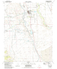
1982 Map of Lone Pine
USGS Topo · Published 1983About this map
The high-desert terrain of the Eastern Sierra dominates this study of Lone Pine and the surrounding Inyo County landscape. The community is flanked by significant local landmarks, including the Lone Pine Indian Reservation and the distinctive geological formations of the Alabama Hills, while the Southern Pacific tracks run parallel to the Owens River to the east. The map identifies several burial sites essential for genealogical research, such as Mt Whitney Cem, Old Lone Pine Cem, and Pioneer Cem.
Find a feature on this map
48 named features on this map. Tap any name to fly to it.
Don’t see what you’re looking for? This feature index may not catch every label — zoom into the map to look around manually.
Map Details
Editions of this 1982 Lone Pine Map
2 editions found
Other maps of this area

1905 · Olancha
USGS Topo · 1:125,000

1907 · Olancha
USGS Topo · 1:125,000

1907 · Mt. Whitney
USGS Topo · 1:125,000

1908 · Ballarat
USGS Topo · 1:250,000

1913 · Ballarat
USGS Topo · 1:250,000

1919 · Mt. Whitney
USGS Topo · 1:125,000

1937 · Mt. Whitney
USGS Topo · 1:125,000

1948 · Death Valley
USGS Topo · 1:250,000

1948 · Fresno
USGS Topo · 1:250,000

1950 · New York Butte
USGS Topo · 1:62,500