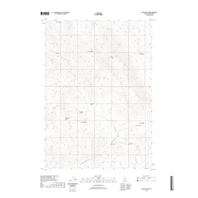
2020 Map of Lone Pine Peak
USGS Topo · Published 2020About this map
Lone Pine Peak serves as the central anchor of this Custer County landscape, where the terrain is defined by a series of high-altitude basins and canyons. The presence of numerous water sources, such as Jenson Cabin Spring, Sorrel Spring, and Tub Spring, suggests a legacy of stock raising or seasonal encampments in an otherwise arid environment. The map details a complex network of drainages and geographic depressions including Germer Basin, Bradshaw Basin, and the smaller Little Bradshaw Basin. Transportation through this high country is dictated by the relief, with routes like Spar Canyon Rd and Malm Gulch Rd following the natural contours of the earth. Unique identifiers like Gray Stud Spring and Red Lake provide specific points of interest for those tracing the historical movement of people and livestock through the Salmon River mountains region.
Find a feature on this map
27 named features on this map. Tap any name to fly to it.
Don’t see what you’re looking for? This feature index may not catch every label — zoom into the map to look around manually.
Map Details
Editions of this 2020 Lone Pine Peak Map
This is the sole edition of this map. No revisions or reprints were ever made.
Other maps of this area

1929 · Bayhorse
USGS Topo · 1:125,000

1957 · Challis
USGS Topo · 1:250,000

1960 · Challis
USGS Topo · 1:250,000

1963 · Challis
USGS Topo · 1:250,000

1963 · Bald Mountain
USGS Topo · 1:24,000

1963 · Bayhorse
USGS Topo · 1:24,000
1963 · Ziegler Basin
USGS Topo · 1:24,000
1963 · Little Antelope Flat
USGS Topo · 1:24,000

1963 · Clayton
USGS Topo · 1:62,500

1963 · Lone Pine Peak
USGS Topo · 1:62,500