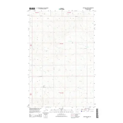
2014 Map of Lone Pine School
USGS Topo · Published 2014About this map
Lone Pine School stands as a focal point in this 2014 record of rural McCone County, where a sparse network of section roads connects isolated homesteads across the Montana high plains. The landscape is defined by the drainage patterns of multiple creek systems, including Presserville Cr, Coal Cr, and the E Fork Sand Cr. Cultural sites are few but significant for local history, notably the Holy Eucharist Cem located along the western edge of the quadrangle. The township-and-range grid is clearly visible through the alignment of local routes like Austrian Rd and Hubbard Rd, illustrating the systematic settlement of this agricultural region. This map provides a detailed view of the terrain before later developments, showing the relationship between water sources like Wolf Cr and the placement of the area's few early institutions.
Find a feature on this map
19 named features on this map. Tap any name to fly to it.
Don’t see what you’re looking for? This feature index may not catch every label — zoom into the map to look around manually.
Map Details
Editions of this 2014 Lone Pine School Map
This is the sole edition of this map. No revisions or reprints were ever made.
Other maps of this area

1954 · Glendive
USGS Topo · 1:250,000

1957 · Glendive
USGS Topo · 1:250,000

1958 · Glendive
USGS Topo · 1:250,000

1983 · Hudiburgh Reservoir
USGS Topo · 1:24,000
1983 · Gady Coulee
USGS Topo · 1:24,000

1983 · Dailey Spring
USGS Topo · 1:24,000

1983 · Hudiburgh Reservoir NW
USGS Topo · 1:24,000

1983 · Beery Reservoir
USGS Topo · 1:24,000
1983 · Lone Pine School
USGS Topo · 1:24,000
1983 · Rock Creek
USGS Topo · 1:24,000