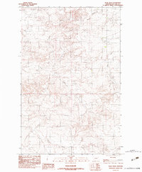
1983 Map of Rock Creek
USGS Topo · Published 1983About this map
The high plains of eastern Montana's McCone County are defined by a complex drainage network shown here as it existed in the late 1970s and early 1980s. The landscape is dominated by the winding course of Rock Creek, which carves through the undulating terrain alongside several significant tributaries. In the northeastern portion of the sheet, Nickwall Creek and Sheep Creek intersect with the local topography, while Long Branch Creek moves through the southern reaches. Human presence is sparse in this open country, marked primarily by the settlement of Earnham and the established boundaries of Township 25 and 26 North. This provisional mapping captures the region's character as a remote ranching or agricultural landscape, where water sources like Rock Creek dictated the placement of early homesteads and transport routes.
Find a feature on this map
6 named features on this map. Tap any name to fly to it.
Don’t see what you’re looking for? This feature index may not catch every label — zoom into the map to look around manually.
Map Details
Editions of this 1983 Rock Creek Map
This is the sole edition of this map. No revisions or reprints were ever made.
Other maps of this area

1912 · Chelsea
USGS Topo · 1:62,500

1916 · Wolf Point
USGS Topo · 1:62,500

1954 · Glendive
USGS Topo · 1:250,000

1954 · Wolf Point
USGS Topo · 1:250,000

1957 · Glendive
USGS Topo · 1:250,000

1958 · Wolf Point
USGS Topo · 1:250,000

1958 · Glendive
USGS Topo · 1:250,000

1972 · Chelsea SW
USGS Topo · 1:24,000

1972 · Wolf Point
USGS Topo · 1:24,000

1972 · Macon
USGS Topo · 1:24,000