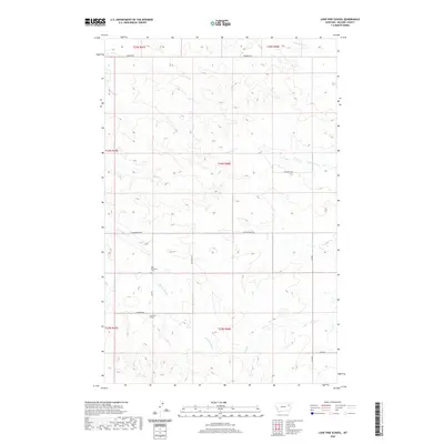
2020 Map of Lone Pine School
USGS Topo · Published 2020About this map
Lone Pine School and the Holy Eucharist Cem serve as the primary cultural landmarks in this rural McCone County landscape. The terrain is defined by a dense network of coulees and drainage systems, including the central Presserville Cr and Coul Cr, which flow through the dissected uplands. The road network, including Vida West Rd and Austrian Rd, follows the section lines and natural topography typical of Montana's eastern plains. This modern survey illustrates the persistent rural character of the region, where watercourses like Wolf Cr and E Fork Sand Cr dictate the movement across the range. The area remains sparsely populated, with development concentrated along established routes such as Hubbard Rd and Lunde Rd, preserving a layout that reflects over a century of township and range surveying.
Find a feature on this map
21 named features on this map. Tap any name to fly to it.
Don’t see what you’re looking for? This feature index may not catch every label — zoom into the map to look around manually.
Map Details
Editions of this 2020 Lone Pine School Map
This is the sole edition of this map. No revisions or reprints were ever made.
Other maps of this area

1954 · Glendive
USGS Topo · 1:250,000

1957 · Glendive
USGS Topo · 1:250,000

1958 · Glendive
USGS Topo · 1:250,000

1983 · Hudiburgh Reservoir
USGS Topo · 1:24,000
1983 · Gady Coulee
USGS Topo · 1:24,000

1983 · Dailey Spring
USGS Topo · 1:24,000

1983 · Hudiburgh Reservoir NW
USGS Topo · 1:24,000

1983 · Beery Reservoir
USGS Topo · 1:24,000
1983 · Lone Pine School
USGS Topo · 1:24,000
1983 · Rock Creek
USGS Topo · 1:24,000